Geography Daily Dose
WBCS Syllabus and Study Materials for Geography
Today's Learning:- Durand Line : Pakistan and Afghanistan
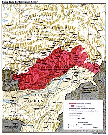
- McMohan Line : India and China
- Radcliffe Line : India and Pakistan
- India West to East Length : 2933 km
- India North to South Length : 3214 km , The 7th Largest Country in the World with World's second largest population.
- IST line goes through Mirzapur,Uttar Pradesh, 82°30'E
- India has 29 states and 7 Union Territories. Rajasthan is the largest and Goa is the smallest.
- The Ocean which touches the American and Asian Shores is the Pacific Ocean.
- The Nagarjuna project is constructed on the river - Krishna - a river originates near Mahabaleshwar
- Father of white revolution - V. Kurien - Also the co-founder of Amul,NDDB - Made India the
the largest producer of milk.wikipedia - Hirakud Dam on Mahanadi River - the largest earthen dam in the world -
See the route and location of th dam here - 24% of India is covered with forest
- Highest mountain peak of the Eastern Ghat is Jindhagada.
- Largest man-made lake in India is Govind Vallabh Pant Sagar.
- India has 247 islands ,204 among them are in Bay of Bengal.
The Durand line (2430 km) was established in 1896 between Sir Mortimer Durand, a British diplomat posted at British India, and
Abdur Rahman Khan,a Afghan Amir. For more click here .
This line is proposed by Sir Henry MacMohan in Simla Accord but considered invalid by both the Chinese and Tibetian Government. Though it is officialy accepted by India in 1935. Tibetian Govt. agreed that Arunachal Pradesh is a part of India but Chinese Govt. is not in accord with the proposal.
Published on 17 Aug,1947, dividing 175000 square miles of territory with 88 million people.
 Radcliffe Line


Comments
Post a Comment